Josephine Avenue is built on land known as Rush Common and as the name suggests, this was originally a piece of marshy common land stretching from the top of Brixton Hill to the town centre. Running through the avenue was a tributary to the River Effra that now runs underneath Effra Road, going north under Brixton Road, the Oval Cricket Ground and emerging as a storm drain next to Vauxhall Bridge.
Old maps show a ‘Rushy Green’ to the South of Stockwell and another place named Brixton Causeway. Legend says that the Oak Tree outside 40 Josephine Avenue was a favourite picnic spot for Queen Elizabeth I when visiting Sir Walter Raleigh (Raleigh’s house stood not far away the other side of Brixton Hill).
In 1806 an Act of Parliament enclosed the land, making it private property but retaining its open character by stipulating that there should be ‘no building or erection above the surface of the earth’ on the boundaries enclosing the former common, a requirement that still stands today.
Development History:
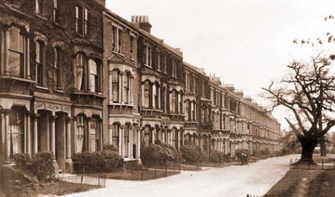
Current housing with some more recent exceptions was built in about 1870 with three-storey terraces. The housing, taking in adjacent streets, forms one of London’s earliest experiments in planned housing designed for a mixed socio-economic group. A builder acquired the land in 1868 for this purpose. Trams connected the area with central London from the 1870s.
The largest houses on Josephine Avenue would generally have had one live-in servant; the smaller two-storey houses on roads leading off the street would not. Some of those two-storey buildings are double-fronted, others single-fronted.
The land to the front of much of the housing is extensive compared to that found in some other Victorian terraces in the wider area. Originally, there were carefully marked-out paths, flat gravel areas, perhaps a tennis court, and two-horse carriageways running in front of the houses. There were fewer above-ground structures to the front of properties than there are currently; boundaries were marked rather than fenced. The adjoining streets of two storey Victorian terraces would have included stables.
The original metal railings that ran along pavements on both sides were lower than those there now. They ran along the top of a low wall made of stone and were removed for scrap during the Second World War. That wall is no longer evident. In the decades between the war and the 1960s and 1970s upkeep of the street declined. By the 1980s it was very run down and considered dangerous, particularly at night. Fly-tipping and street crime were endemic. In the 1970s local residents had already organised themselves address issues of concern, and the environment we enjoy today is largely thanks to them and their successors in the 1980s.